


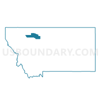
Precinct 28, Pondera County, Montana
About
Outline

Summary
| Unique Area Identifier | 612205 |
| Name | Precinct 28 |
| County | Pondera County |
| State | Montana |
| Area (square miles) | 542.63 |
| Land Area (square miles) | 542.16 |
| Water Area (square miles) | 0.48 |
| % of Land Area | 99.91 |
| % of Water Area | 0.09 |
| Latitude of the Internal Point | 48.21151580 |
| Longtitude of the Internal Point | -111.84281470 |
Maps


Graphs
Select a template below for downloading or customizing gragh for Precinct 28, Pondera County, Montana


Neighbors
Neighoring Voting District (by Name) Neighboring Voting District on the Map
- Precinct 1, Liberty County, MT
- Precinct 19, Pondera County, MT
- Precinct 23, Pondera County, MT
- Precinct 24, Pondera County, MT
- Precinct 27, Pondera County, MT
- Precinct 35, Pondera County, MT
Top 10 Neighboring County Subdivision (by Population) Neighboring County Subdivision on the Map
- Shelby CCD, Toole County, MT (4,075)
- Conrad CCD, Pondera County, MT (3,769)
- Choteau CCD, Teton County, MT (3,146)
- Fort Benton CCD, Chouteau County, MT (2,357)
- Chester CCD, Liberty County, MT (2,071)
- Valier-Dupuyer CCD, Pondera County, MT (1,539)
Top 10 Neighboring Place (by Population) Neighboring Place on the Map
Top 10 Neighboring Elementary School District (by Population) Neighboring Elementary School District on the Map
- Shelby Elementary School District, MT (3,829)
- Conrad Elementary School District, MT (3,385)
- Chester-Joplin-Inverness Elementary School District, MT (2,190)
- Valier Elementary School District, MT (981)
- Pendroy Elementary School District, MT (312)
- Miami Elementary School District, MT (255)
- Knees Elementary School District, MT (168)
Top 10 Neighboring Secondary School District (by Population) Neighboring Secondary School District on the Map
- Shelby High School District, MT (4,092)
- Conrad High School District, MT (3,640)
- Choteau High School District, MT (3,118)
- Chester-Joplin-Inverness High School District, MT (2,463)
- Fort Benton High School District, MT (2,296)
- Valier High School District, MT (1,355)
Top 10 Neighboring Unified School District (by Population) Neighboring Unified School District on the Map
Top 10 Neighboring State Legislative District Lower Chamber (by Population) Neighboring State Legislative District Lower Chamber on the Map
- State House District 28, MT (9,406)
- State House District 27, MT (8,795)
- State House District 17, MT (8,272)
Top 10 Neighboring State Legislative District Upper Chamber (by Population) Neighboring State Legislative District Upper Chamber on the Map
Top 10 Neighboring 111th Congressional District (by Population) Neighboring 111th Congressional District on the Map
Top 10 Neighboring Census Tract (by Population) Neighboring Census Tract on the Map
- Census Tract 9770, Pondera County, MT (3,769)
- Census Tract 2, Toole County, MT (3,456)
- Census Tract 9772, Pondera County, MT (2,384)
- Census Tract 501, Liberty County, MT (2,339)
- Census Tract 102, Chouteau County, MT (2,125)
- Census Tract 1, Teton County, MT (1,819)
Top 10 Neighboring 5-Digit ZIP Code Tabulation Area (by Population) Neighboring 5-Digit ZIP Code Tabulation Area on the Map
- 59474, MT (3,820)
- 59425, MT (3,751)
- 59486, MT (1,328)
- 59416, MT (337)
- 59467, MT (259)
- 59456, MT (233)
- 59432, MT (104)